GPSMAP 9027 Premium 27" Chartplotter with Worldwide Basemap

The industry’s first integrated 4K resolution touchscreen chartplotter. Enjoy edge-to-edge clarity and luxury on a glass helm with premium design and materials plus enhanced connectivity and speed.
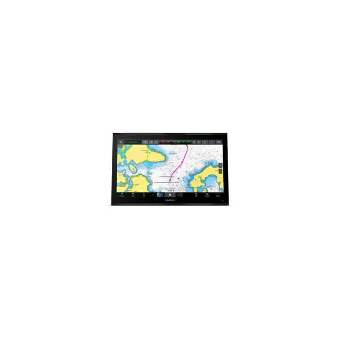
Welcome to the future of boating with the industry's first integrated 4K touchscreen chartplotter, the Garmin GPSMAP 9027. This powerhouse delivers unmatched clarity and luxury on a stunning 27-inch glass helm display. Take command of your vessel with:
- Unparalleled Visuals: Crystal-clear 4K resolution ensures exceptional detail and sunlight readability, even on the brightest days.
- Blazing-Fast Performance: Enjoy smooth operation and near-instantaneous chart rendering thanks to up to 7 times faster processing power compared to previous models.
- Seamless Connectivity: Experience the power of gigabit speeds on the Garmin BLUENET network for effortless data transfer and minimal lag.
- Ultimate Customization: Integrate video feeds from cameras and other sources directly onto your chartplotter display for a unified viewing experience.
- Unmatched Charting: Navigate with confidence with compatible Garmin Navionics+ charts, offering the most comprehensive and up-to-date marine cartography available.
- Network Like a Pro: Connect with multiple chartplotters, cameras, and sonars to create a customized network that fits your needs.
- Sonar Like Never Before: See fish and underwater structures with remarkable detail with high-definition sonar support (sonar module sold separately).
- Total Control: Achieve complete system integration by monitoring, automating, and controlling your vessel through the chartplotter (requires compatible digital systems).
Elevate your boating experience and take full command with unparalleled visibility, unmatched processing power, and seamless connectivity.
Includes:
- GPSMAP 9027 chartplotter
- Trim snap cover
- Protective cover
- Flush mount hardware
- Power cable
- GPS 24xd NMEA 2000 (with pole mount, flush mount and under deck mount adapters)
- NMEA 2000 backbone/drop cable (2 meters)
- NMEA 2000 power cable
- NMEA 2000 T-connector and terminator kit
- Documentation
| Part Number | 010-02676-00 |
|---|---|
| Features | WELCOME TO 4K PARADISE It’s the industry’s first integrated 4K resolution touchscreen chartplotter. Enjoy edge-to-edge clarity and luxury on a glass helm with premium design and materials plus enhanced connectivity and speed. PREMIUM CHARTPLOTTERThe 4K resolution IPS sunlight-readable touchscreen display is available in the industry’s largest integrated chartplotter size. Edge-to-edge design provides a seamless and luxurious modern look. FASTER. MUCH FASTER.Processing power is 7 times faster than previous generations for superior performance; draw charts quickly, and calculate Auto Guidance+ routes with lightning speed with an optional Garmin Navionics+ subscription. GARMIN BLUENET NETWORKBuild extensive networks with multiple chartplotters, cameras, radars and sonars — and enjoy 10 times faster networking speeds with minimal lag. ENTERTAINMENT OPTIONSEnjoy audio and video integrations that allow you to show and hear the same video throughout the screens and speakers on your network. HIGH-DEFINITION SONARFish in stunning high definition. Hook up to any of our sonar modules, and view sonar targets on the 4K display (transducers sold separately). CONNECT YOUR ECOSYSTEMTake command through digital system integrations to monitor, automate and control your vessel. The chartplotter uses the NMEA 2000 and NMEA 0183 networks to connect to your compatible accessories. |
| Specs | Physical & PerformanceDisplay Size: 23.5" x 13.2" x 27.0" diagonal, 59.7 cm x 33.6 cm x 68.5 cm diagonal Power Input: 10 to 35 Vdc Display resolution: 3840 x 2160 pixels GPS: Yes Dimension: 25.8" x 16.7" x 3.3" (65.5 cm x 42.3 cm x 8.5 cm) Receiver: 10 Hz (included receiver) Waterproof: IPX7 Weight: 27.65 lbs (12.54 kg) Mounting Options: Flush or flat Display Type: 4K, IPS
Maps & NavigationGarmin Navionics Vision+: Yes Accepts Data Cards: 2 SD Cards Garmin Navionics+ (Inland): No Garmin Navionics+: Yes
FeaturesWaypoints: 5000 Sailing Features: Yes NMEA 0183 Compatible: Yes Has built-in receiver: No USB ports: yes (2x USB-C) TOPO 100K: Yes SideVü: yes (with compatible black box sonar) DSC: Yes Touchscreen: Yes LakeVü g3 Ultra: Yes NMEA 2000 Compatible: Yes ActiveCaptain compatible: yes Typical current draw at 12 Vdc: 7.2A NMEA 2000 ports: 1 Tide tables: No Panoptix sonar: Yes LakeVü g3: Yes Supports WAAS: Yes GSD Black Box Sonar Support: Yes Maximum current draw at 12 Vdc: 8.1A Smart Mode Compatible: Yes Maximum power usage at 10 Vdc: 97W BlueChart g3: No Standard Mapping: Yes Garmin BlueNet network ports: 4 LakeVu (inland): No Built-in Auto Guidance+: No Displays sonar: Yes ANT+ (Connectivity): Yes GCV Black Box Sonar Support: Yes BNC external GPS antenna port: No Connections NMEA0183 Input Ports: 4 Spoken audio alerts: Yes BlueChart g3 Vision: No Garmin Wi-Fi network (local connection): Yes J1939 ports: 1 Audio output: Yes Input: Touchscreen BeiDou: Yes Garmin Quickdraw Contours: Yes BLUETOOTH pairing: Yes AIS: Yes Supports multi-band, multi-constellation GPS: Yes Video output ports: 1 HDMI Compatible with Garmin SD card reader: Yes Raster chart support: Yes NMEA 0183 output (Tx) ports: 2 OneHelm support: Yes ClearVü: yes (with compatible black box sonar) Wireless Remote Compatible: Yes Supports Fusion-Link™ compatible radios: Yes LiveScope: Yes Traditional sonar (dual frequency/beam): yes (with compatible black box sonar) GRID (Garmin Remote Input Device) compatible: Yes Video input ports: 1 (BNC composite); 2 HDMI (HDCP compliant) |
| Brand | Garmin |